Is this Steve Fossett? The community searches.
UPDATE 1: My contact at mTurk received the coordinates and passed them to the experts. The story continues...
UPDATE 2: Some people have pointed out that the plane could be flying. Look below for my analysis of this. Basically I need to remember more about geometry, but two things keep me hopeful: the plane is the right size and the "shadow" seems to come from the North.
As if they were writing a how to manual for the Internet community, WIRED Magazine ran a story only a few months ago about the search for Jim Gray, presumed lost at sea.
Part of the story told of how thousands of people joined the search for the missing Silicon Valley legend by browsing through thousands of satellite images on Amazon's Mechanical Turk.
Today, the Internet community and MTurkers were called into action to find another ledgend: American aviator, Steve Fossett, lost since last Tuesday.
When I got an email from Amazon to pitch in, I went to the website immediately to participate in what seemed to me was an extraordinary display of community and the power of community. Because the search for Mr. Fossett was so much about community, I also forwarded the email to the nextNY and NY Tech Meetup email lists, of which I am an active member.
After doing 80 HITs (tasks, looking at images on mTurk), I had to leave my house. During that time, I had one frame which looks suspicious, but to no avail. However, when I got home, I saw an email from Paul Norris, who had read my email on one of the lists:
Hi Nate,
I’m a big fan of the guy so went looking. First hit I found a “plane”: 38°28'55.90"N 119°24'18.75"W But then Google Earth crashed. Check it out and send it on, if you have a contact. It may just be one of the many other lost planes…
Paul
Sure enough, if you load those coordinates on Google Earth (along with this super important .kml file from Google), there you see a place. Turn off the new layer, and its gone (which means it could be pretty recent).
Anyway, I'm about to write an email to someone I met at Web 2 Expo who works in the mTurk division, but if you know someone specifically who works there, here's a positive hit which never got in the engine.
This could be Steve Fossett.
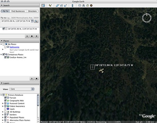
Click the thumbnail to see it larger, or click here to see the photo to see on Flickr.
UPDATE: Some people have pointed out that the plane could be in flight. I'm not remembering everything I need to know about geometry right now, but I would imagine that there would be some sort of enlargement to the plane if it was flying, though considering these are satellite photos, that could be very negligible.
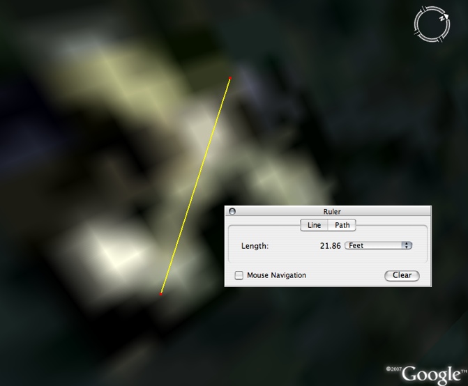
Anyway, check out the measurements I did on Google Earth, and reference the diagram below, provided by Amazon, which shows the plane is the right size, more or less (note that the edged of the plane were pixelated, so I measured from the center of the outer fuzziness).
The only other issue is what some folks think is a shadow (which would indicate that the plane is in flight). I think that's plausible, but it also seems that the "shadow" is to the south of the plane, which -- if I remember this correctly -- doesn't make much sense (wouldn't something in the northern hemisphere have a shadow to its north?). Of course the mountain under it could be affecting the shadow as well.
 Click the thumbnail to see it larger, or click here to see the photo to see on Flickr.
 Digg this to raise awareness.